THE CORVALLIS MILL RACE (Last Updated 11/3/2018)
Phillip Sollins, Professor of Forest Ecology and Soils, Emeritus
College of Forestry, Oregon State University
The Corvallis Mill Race, first constructed in the 1860s, led a trouble-free and purposeful life for over 100 years. A diversion dam on the Marys River channeled water into the Mill Race where water stayed cool even in the summer. In the late 1940s cut-throat trout still used it to by-pass the diversion dam and reach spawning grounds in the upper Marys River; some residents kept boats along the Mill Race shores. In 1948 Chapco (later Evanite) stopped using the Mill Race as a power source and discontinued maintenance of the diversion dam. The diversion dam was bypassed by Evanite in the summer of 1967, without consultation with City or County. This stopped all water flow from the Marys River into the Mill Race, converting it into an "urban orphan" and raising many questions about its long-term utility and fate. In the rainy season, runoff from roofs, roads, and parking lots (termed impermeable area), along with ground-water seepage continued to provide low-level water flow, but in the dry season flow stopped and the remaining ponds became stagnant. Vegetation was allowed to grow in the channel, trash accumulated, and the Mill Race became more of an eye-sore and nuisance than a neighborhood resource.
Here I explain what's known of the history of the Mill Race and discuss its current state (2017) and possible opportunities for returning it to its former status as a neighborhood resource. In what follows, clicking on most of the aerial photos will bring up the full-resolution and full-size version as originally scanned (jpg file) that can be zoomed as desired. The highest resolution photos may take a while to download (especially the 1940), but, once downloaded, you can save them to your computer.

South Corvallis in 2015
South Corvallis in 2015 but with the original alignment of the Mill Race shown in purple. Note that Crystal Lake Dr. (CLD) has been rerouted at least 4 times over the years.
Until about 1929, Crystal Lake Dr. (CLD) began at 99W, where Chapman Pl. is now located, and proceeded in a straight line to the flour mill where it stopped. Some time earlier a road bridge was built across the Mill Race at the flour mill and the road was gradually extended southward, mainly to provide access to Corvallis Sand and Gravel.
By 1965 Evanite operated manufacturing plants on both sides of CLD. In 1967 the downstream end of the Mill Race was relocated from its historical position to empty into the Marys River instead of the Willamette River (much more about this later).
In 1984, both at the urging of Evanite and in order to eliminate the dangerous intersection at CLD and 99W (immediately south of the two bridges over the Marys), the western end of CLD was relocated to its present position, intersecting 99W at Avery Ave. The portion of CLD that had passed through the Evanite operation was closed to the public, and the extreme western end was renamed, first Pioneer Place, then Chapman Place. At that time the Mill Race south of the railroad spur was relocated to its present position and the new CLD built in part atop the old channel. The location of the former diversion dam is also shown.
In 1996, Evanite was bought out of bankruptcy by Hollingsworth & Vose, a privately held company with headquarters in Masachusetts. H&V assumed all liability for clean-up of the massive leakage of tri-chloroethylene (TCE) into soil and ground-water by Evanite dating back at least to the 1980s.

LIDAR Shaded Relief (acquired 2008)
This rendering assumed the sun was in the northwest, thus banks facing NW appear in white as if receiving direct sunlight. It shows the Mill Race as relocated in 1967 and 1985 and Crystal Lake Drive as relocated in 1984. Evident also are the swales trending NW across the former golf course and the abandoned Marys River meanders west of the former inlet to the Mill Race.
South Corvallis Pre-1800??
Photo of Jackson-Frazier Park (Oregonhikes.net)
Pre-1800, parts of South Corvallis probably looked much like this – for example where wet prairie bordered riparian forest along the Marys River (see next photo. By the early 1800s, beavers had been extirpated by French trappers who hired Native Americans to do the trapping. Next, the flat land was converted to agriculture by clearing forest and ditching wetlands. All of this led to well incised channels where none had existed before. This incision and drainage drastically reduced wildlife habitat and changed the flood dynamics of the entire Willamette Valley.

Map of 1854 Vegetation in South Corvallis
Vegetation in the early 1850s (with current streets shown). The Mill Race channel was dug by Chinese labor following an existing wetland drainage path upstream to where Allen St. now ends. The new channel then turned almost due west toward the Marys River. At least two tributary drainage paths flowed into Mill Race path. The eastern one is termed here Bridgeway Cr. in honor of its having been obliterated by the residential development along Bridgeway Ave. The western one is termed here Leonard Cr. for an analogous reason. Original map by Denis White based on a paper by Christy and Alverson (2011).
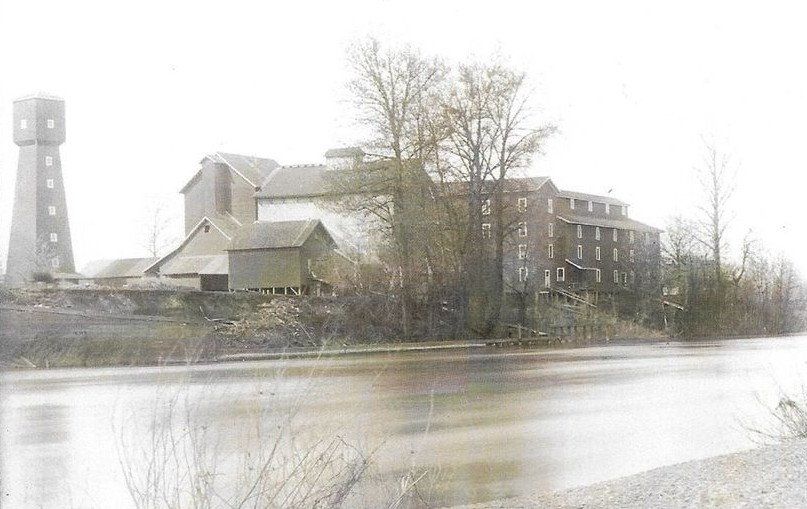
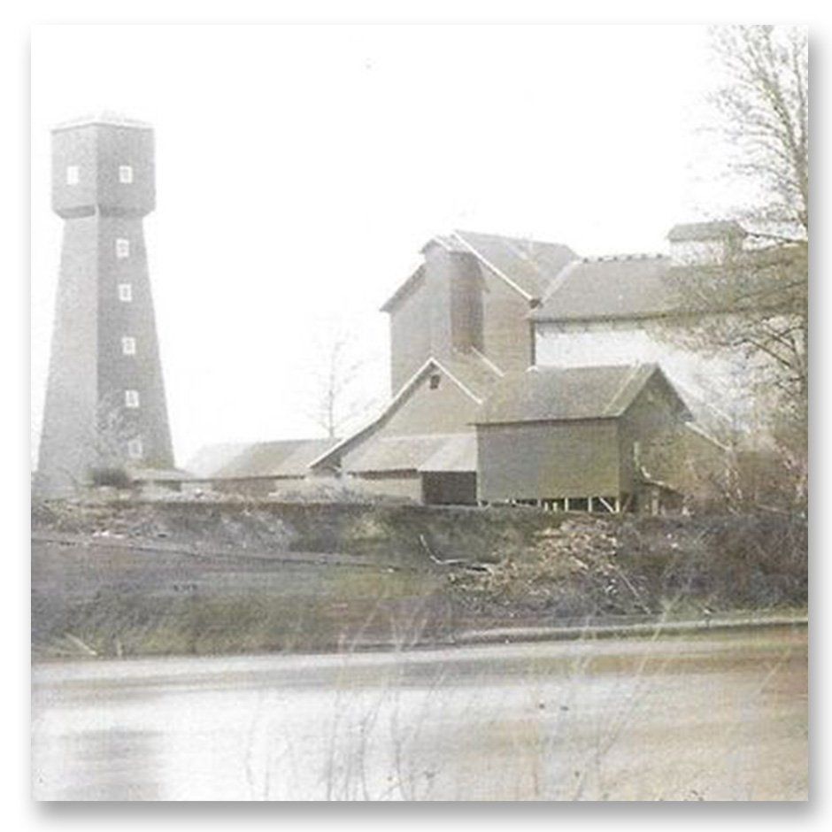
Flour Mill Wheel Ground Grain by Water Power
Fischer Mill, along the west bank of the Willamette, was powered by water from the Mill Race. It was built by J.C. Avery in 1855 to replace a saw mill built in 1850. The tower on the left appears also in the next photo.
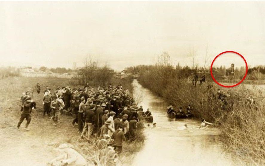
Mill Race Delivered Steady Water Supply to Mill
This photo from the early 1900s shows the annual tug-of-war between students at OSU and U of O held in conjunction with the “civil war” football game. Note the tower visible in the distance on the right.
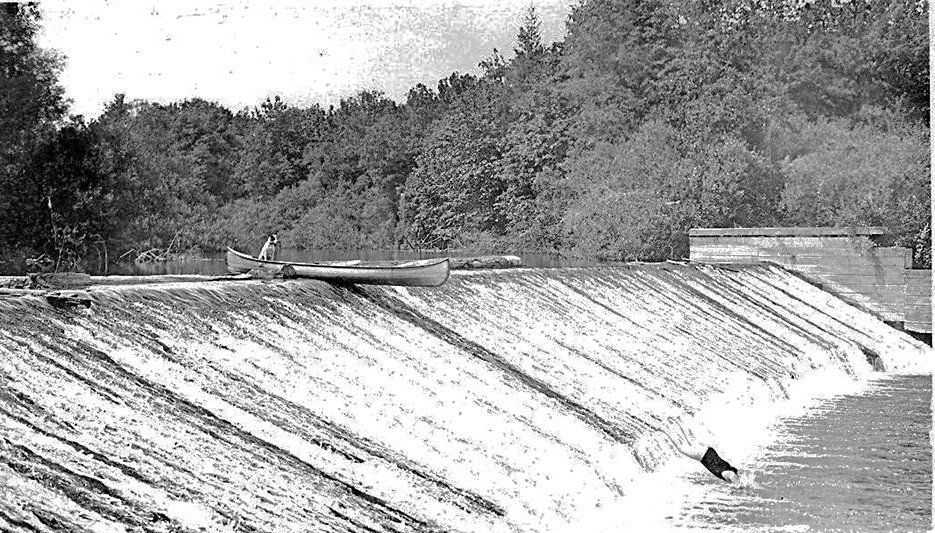
Diversion Dam, ca. 1915
The dam was a popular recreation site until maintenance ceased around 1950.

Diversion Dam in 1960 after Addition of Fish Ladder
The diversion dam was reconstructed in 1948 by Chapco (Ralph Chapman, owner) in an unsuccessful attempt to use a water-powered turbine to drive its hardboard plant. A fish ladder (extreme right end of dam) was added at this time. The dam was bypassed by Evanite in 1967 by digging a new channel to the west of the fish ladder, leaving, as best can be determined, the entire dam in place.
Photo by Fisheries Commision of Oregon (1960).

Abandoned Sluice Gate
Partitioned water flow between the mill and an overflow spillway
The sluice gate in 2014. It was abandoned in 1967, when the Mill Race was rerouted as a surface ditch north across Evanite into the Marys River. The adjacent upstream and downstream channel reaches were not back-filled until 1984. A 1927 Sanborn map shows a "gate" in this location but the exact date for construction of the current structure remains unknown.
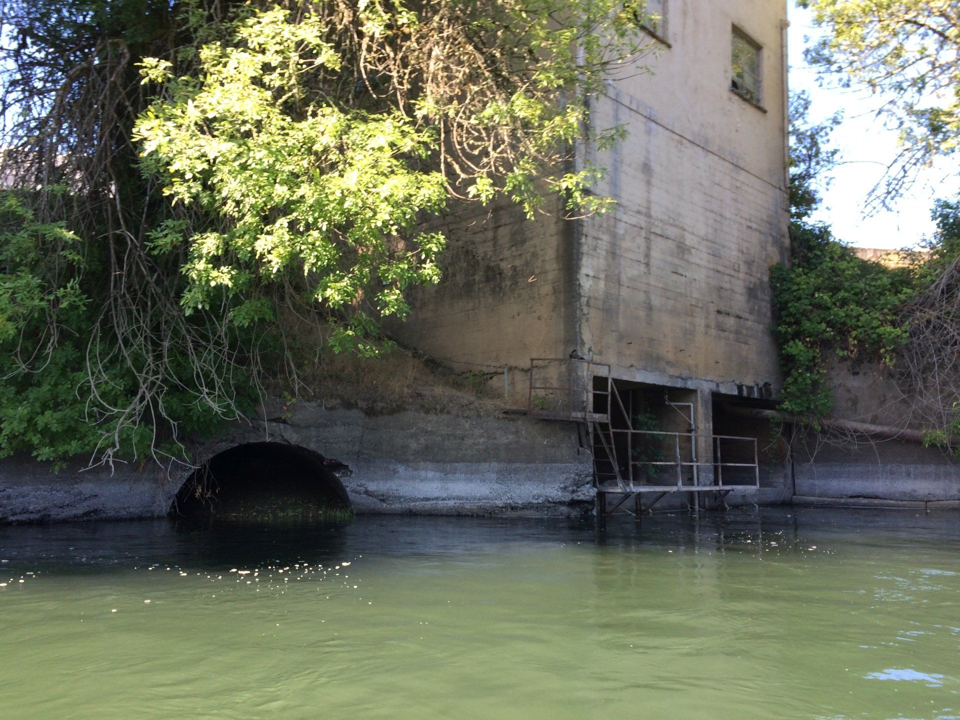
Abandoned Mill Race Outlet to Willamette R. (2017)
(Photo by Kathleen Westly, Marys River Watershed Council)
River-side view of the base of the former Evanite hard-board plant in 2017. The rectangular opening served then as the water inlet for the H&V wet-scrubber units. These have since been replaced (see article in G-T by Bennett Hall, 10/4/2018) by dry ceramic filters that are more effective and eliminate all but a very small fraction of the former water use by H&V.

Marys River and Diversion Dam in 1936
The Mill Race dam and inlet in 1936 (aerial photo). Note the very straight and wide reaches immediately upstream (SW) and downstream (NW) from the dam. These reaches were probably excavated in 1855 when the dam was rebuilt a third time after two previous dams had failed. By straightening these stream reaches the water flow from upstream was better aligned perpendicular to the dam. Spoil from the upstream excavation appears to have been piled along the east bank of the river, creating a berm that has since prevented the Marys from overflowing along this part of the river. It overflows instead just upstream of the former Marysville Golf Course. The flood waters then travel NE toward the railroad berm creating the swale topography seen at center bottom of the photo. The dam was last rebuilt in 1948, at which time a concrete fish ladder was constructed adjacent to the western end of the dam.
Downstream from the dam, a shorter reach of the of the Marys was likely also straightened.
Note also the abandoned river meanders to the NW of the new channel. These “magically” appeared on the 1939 USGS Corvallis quadrangle map as shown on the next several slides.
A Curious Episode in the Mill Race History
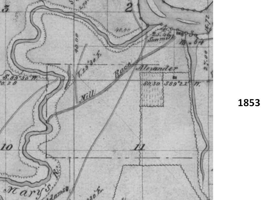
South Corvallis in 1854
Small portion of a map published in 1854 by the General Land Office. Note that the Mill Race is shown as beginning just downstream from a substantial bend in the Marys River. However, the earliest aerial photo (1936, see below) shows the Marys as straightened both upstream and downstream from the dam. Territorial Road at that time headed southwest from the ferry crossing on the Marys River, rather than due south as it does today (US 99W).
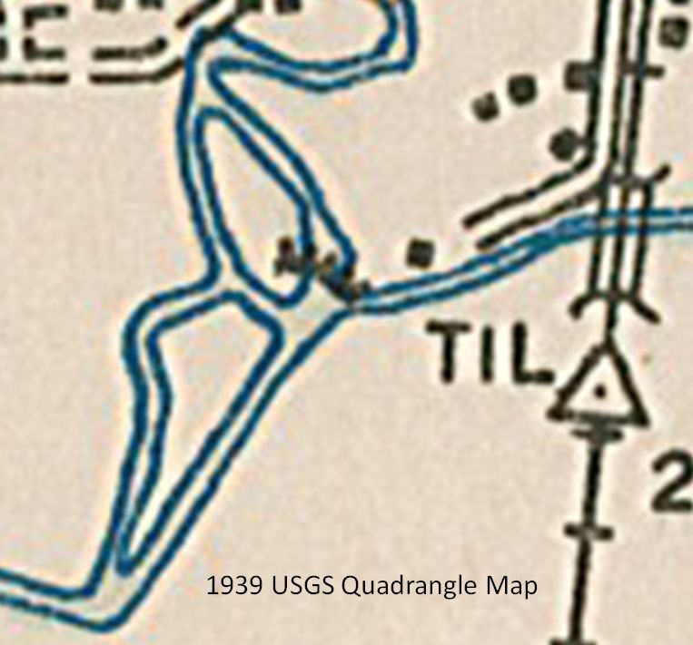
Marys River in 1939
This is a greatly enlarged portion of the 1939 USGS Corvallis Quadrangle map showing the same area as the previous slide. The "islands", bounded to the west by curved water-filled channels, did not appear on earlier versions of this map. Note the almost perfect correspondence between these curved channels and the abandoned horseshoe bends that can be seen in the 1936 and subsequent aerial photos. These curved channels, which still exist (see especially the 2008 Lidar image, above), probably only become water filled when the Marys is at flood stage. The USGS map was based on aerial photography taken by US Army in 1939, possibly during winter when water levels were high and trees were leafless. These channels, ephemeral at best, continued to appear on USGS quadrangle maps until they were finally removed for the 1997 revision.

Modern History of the Mill Race and Adjacent Lands
Area SW of Current Hollingsworth & Vose (H&V) Industrial Site (1921 Survey)
South Corvallis has long been the most heavily industrialized portion of Corvallis. In 1921, three petroleum product storage farms were in place along 99W just S of the now-abandoned Southern Pacific Railroad spur.
The Union Oil lot is now the site of Pacific Pride commercial fueling. The Standard Oil lot has been vacant since about 1980 following removal of the last Dog Face Lumber structures (see below) and has remained undeveloped due in part to soil contamination by Standard Oil or Dogface lumber or both. As of 2018, plans call for a drive-through coffee shop.
Note that the Shell lot (now Corvallis Rental) includes a sliver of land reaching to and eastward along the abandoned railroad spur, used likely to offload petroleum products from rail-tanker cars. If and when the railroad spur is formally abandoned by the railroad (now Union Pacific) that portion will revert to Corvallis Rental.

South Corvallis along 99W between Lilly and Crystal Lake Drive in 1936
Note the small creek draining under the railroad spur about half-way between 99W and the Mill Race, then through what’s now H&V. Remnants of that creek (culvert under railroad spur and various ditches) are still present (2017). Bridgeway Cr. is seen clearly.

Area Along the Mill Race between the Southern Pacific Railroad Spur and US 99W in 1940
Commercial development is almost totally absent. Bridgeway Cr. crosses an obvious east-west property line now forming the N end of the lots along the N side of Bridgeway Ave.

The Log Pond for the Dog Face Lumber Company (Lester Harvey, owner) first appears in this 1948 aerial photo.
The log pond for the Dog Face Lumber Company (Lester Harvey, owner) first appeared in this 1948 aerial photo. The area to the east of the Mill Race was not yet in use for storing saw logs. Bridgeway Ave. was graded but no houses had yet been constructed.

First Houses on Bridgeway (1956)
In this 1956 photo, the first houses appeared along Bridgeway, built on the higher ground well away from the creek and thus safe from flooding. The Dogface Lumber log pond was still in use at this time.

By 1993, Both the Mill Race and Crystal Lake Dr. Had Been Relocated (see below)
At the time of this 1993 color photo, Corvallis Rental and the public storage facility (but not the martial arts studio) had been built over the former log pond, and the railroad spur was still in good condition. Note that almost all riparian vegetation from Evanite upstream to south of the public storage facility was removed as part of the second relocation of the Mill Race in 1985.
Relocation of the Mill Race in 1967
These photos show that between 1965 and 1969, the original Mill Race was closed off just upstream from where Crystal Lake Drive then crossed, and a new channel was dug north across Evanite and then City land to a point on the Marys River just upstream of the confluence with the Willamette River. The new channel ran first NW toward a gap between two Evanite buildings resulting in a left-hand 90 degree turn. Twin 48" culverts, still in place, led under the railroad spur (see photos nelow), and an existing culvert (~20-30' diameter) carried water north under what was then called Chapman Place toward the Marys River. The smaller size of the new ditch, the 90 degree turn where the old channel connected to new, and the undersized culverts likely reduced flow significantly and led to increased flooding in South Corvallis.
Extensive review of both City and County records had failed to yield any records of local government involvement in the planning of this channel realignment. Finally, in 2015, a search of on-line City archives told the story.
City Council minutes for June 19, 1967, state that Evanite personnel met with the City Manager and unspecified staff members to discuss how the Mill Race could be modified to better drain floodwater from the South Corvallis area. Evanite’s interest was presumably prompted by its desire to fill in the Mill Race at its eastern end, to improve access to and around the hardboard plant. Evanite had stopped using their Mill Race water by 1958.
Council minutes for October 2nd state that Mill Race modifications had been made, and included “trespass … across City lands at the mouth of the Mary’s River.” The clear implication is that this was done without City approval or even further consultation. Note also that the minutes refer to use of an existing culvert under Chapman Lane (known at the time as Crystal Lake Drive).
The minutes for October 16, 1967, refer to a Public Works Department report of October 12th that stated that the realignment was indeed done without “consultation or approval of the City of Corvallis.” The City does not have a copy of this October 12th report. It appears, however, that no action was ever taken by the City or County against Evanite, despite clear evidence that the realignment significantly impeded drainage of flood waters from South Corvallis.
The City of Corvallis eventually rebuilt all the affected parts of the Mill Race, much of it at City expense, but the last stage of the work was not completed until 1997, presumably in response to the disastrous flood of 1996.
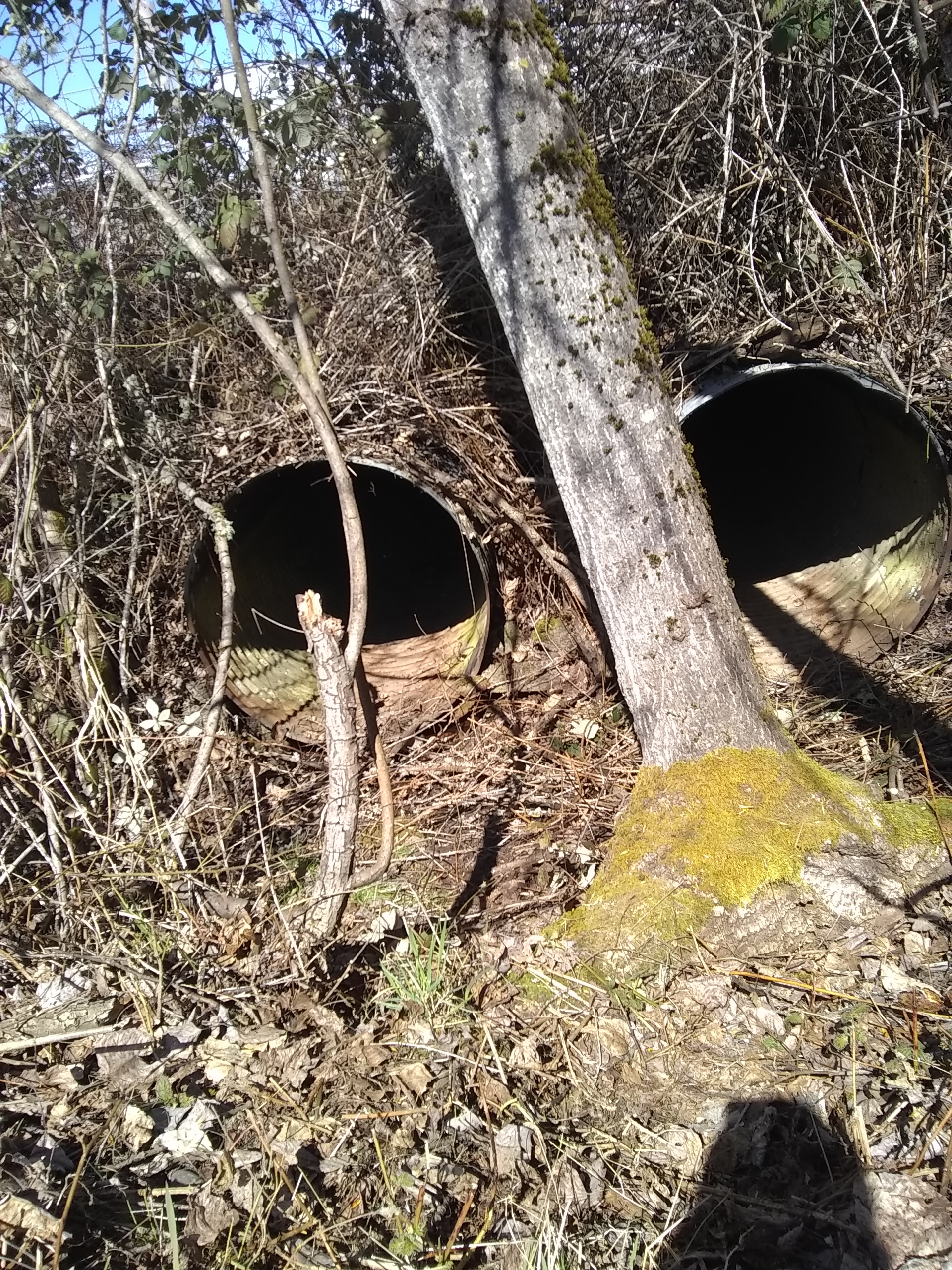
Twin 48" Culverts Channeled Water under the Mill Race
Constructed most likely as part of the illegal relocation of the Mill Race by Evanite in 1967, these culverts open into the giant pit at the south end of the H&V property (see photo below). These survive to this day (2018) but only function when the Mill Race water rises to a level ~5 ft below grade between CLD and the railroad spur. The bottom of the culverts corresponds to the depth of the original MIll Race channel.
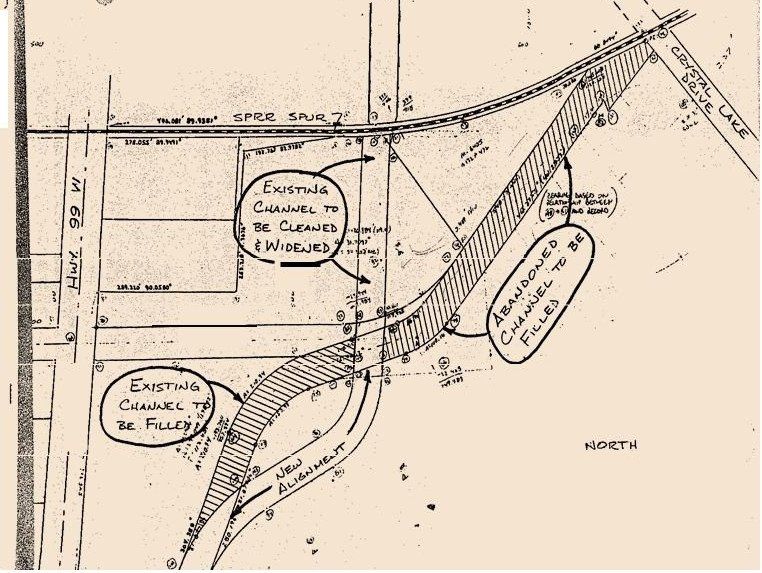
1981 Plan to Relocate Mill Race and Crystal Lake Dr. (CLD)
This work, done in 1984 by Bill Pepper (Pepper Construction), included relocating the Mill Race channel between the CLD bridge and the railroad spur and rebuilding CLD atop the old location of the Mill Race. The new Mill Race channel was dug about 8 ft deeper than the one it replaced. Bill, perhaps unaware of the twin 48" culverts under the railroad spur to the east of the new Mill Race channel, pushed a 20" culvert through the soil under the railroad spur at the N end of the relocated MIll Race (see below).
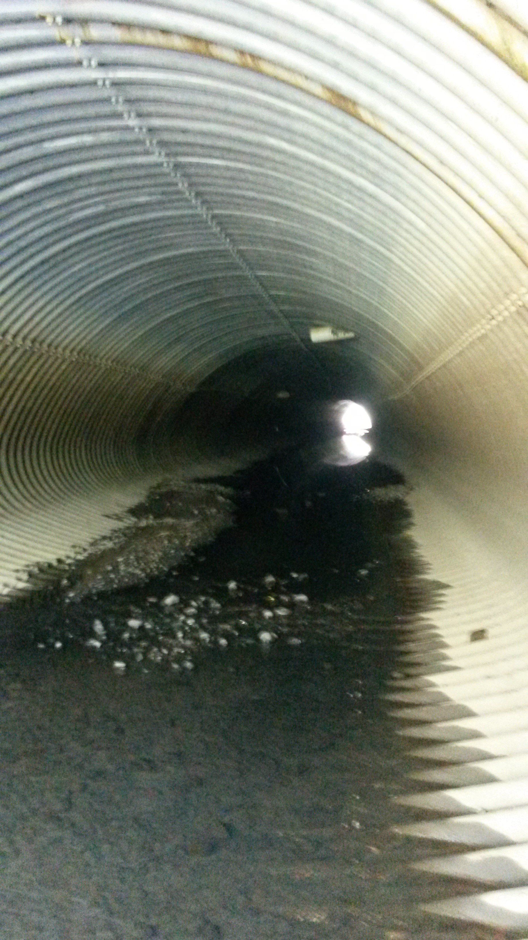
Finished 20 x 12 Foot Culvert Under Evanite
View inside the culvert under Evanite looking north, probably in late spring while the Mill Race was still flowing.

Culvert Under the Railroad Spur Added in 1985
In the early 1980s the City began planning to greatly enlarge the channel through Evanite. In November 1984 Evanite requested that the City enclose the Mill Race in a large buried culvert where it crossed the Evanite property. Evanite agreed to pay the extra costs involved in buying and installing the culvert.
Work began on July 15, 1985, with Paul Lambson Construction as the lead contractor. Bill Pepper (Pepper Construction) had been lead contractor on the Crystal Lake Dr. relocation and still had a track-hoe on site. Bill agreed to run the track-hoe under a subcontract to Lambson. Bill recounted to me that as soon as they started work, chemical fumes of some sort began to be noticeable. The fumes were rapidly identified as tri-chloroethylene (TCE), widely used as a low-cost general anesthetic and by Evanite to remove oil from battery separators. By August 6 fumes had became intolerable and the project was shut down.
The project was restarted on Sept. 23 with CH2M Hill providing equipment to analyze each shovel-full of soil removed by the excavator for TCE. Soil exceeding 20 ppm TCE was trucked to the Arlington hazardous-waste disposal site. It is unclear what was done with soil that tested below this limit. The source of the TCE, the extent of the leakage, and the subsequent successful remediation under the direction and supervision of Seth Sadofsky, Eugene DEQ, are stories in their own right. Even in 2017, however, small amounts of TCE were still being recovered from soil and groundwater.
For reasons still unclear, the large (20x12') culvert was not extended S under the railroad spur at this time. The twin 48" culverts were still in place about 100' to the east but the only connection between the relocated Mill Race and those culverts was a ditch along the tracks. Perhaps because the connection involved two abrupt 90 degree turns, or perhaps because no one was aware of the 48" culverts, a 20" culvert was pushed through the soil under the railroad spur (see photo above). In any case, nothing further was done to facilitate flow under the railroad spur until after the record flood in spring 1996.

1996 Flood at Maximum Extent (Friday, February 9)
The Marys River drains a much smaller area than the Willamette and typically peaks first. Thus by the time the Willamette peaks, the Marys water level has usually already dropped substantially. The 1996 event was unusual in that the Marys peaked on Wednesday (2/7) but then dropped only inches until after the Willamette peaked on Friday, which is when this photo was flown. The Willamette peaked at 219.1 ft (at the old Van Buren St. gauge but converted to NGVD88) . As best we can determine, the combination of near record high-water levels simultaneously on both rivers caused the Marys to overflow its banks south of the then Marysville Golf Course.
On the day of this photo (February 9), water was still overflowing the Marys south of the golf course and flowing under the southern of the two railroad trestles. Water then followed the ditch immediately to the east of the railroad berm until it intersected the Mill Race just east of the northern railroad trestle. From here the flow path split. Some water flowed northeast along the Mill Race despite the back-up of water from the Willamette. The majority, however, flowed west under the railroad trestle, through the Allen St. neighborhood (where Charles Newlin recalls white-water between several of the houses), then back into Marys well upstream from Avery Park. Accounts by several South Corvallis residents are in agreement that flood water was flowing east across US 99W at the Lilly Ave. bridge throughout the week, indicating that the Willamette had not backed water this far upstream in the Mill Race.
Note that the three culverts under the railroad spur (twin 48" and a single 20") had not yet been replaced with the current 20x12 foot culvert. This bottleneck probably contributed to the long duration of the flooding in South Corvallis.
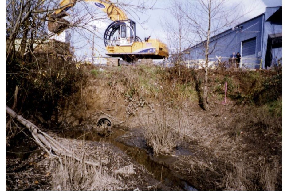
Installation of 20x12 ft. Culvert under SP Railroad Spur
Day 1 (1997) of the culvert replacement under the railroad spur.
Note the 20” diameter pipe that had been in place probably since the Mill Race was relocated a second time in summer of 1984.

Day 2 - Railroad-Spur Culvert Installation
Looking S on day 2 of the excavation. Amazing what two excavators can do in one day, especially with no TCE to worry about. At least four culverts can be seen draining into the excavation. The twin 48" culverts originate on the south side of the railroad berm, perhaps 8 ft. above the current bottom of the Mill Race channel and 100 ft east of the current 20x12' culvert. Little is is known about the two culverts on the right (west) side of the excavation but the larger one may drain the contaminated empty lot between Fireworks and Corvallis Rental.
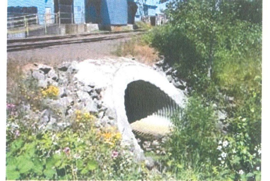
Finished Culvert Under the Railroad Spur
Culvert (20'x12') as installed under the Southern Pacific RR spur (1997)
Note the large size (20'x12') of the finished culvert. The same design and materials used for this culvert were also used in 1985 for the culvert under Evanite.

View upstream from bridge at Crystal Lake Dr.
Photo by Allen Throop (1997)
Note low summer flow. The 1993 and 2000 aerials show almost no trees until upstream from the bend shown in this photo.

View Downstream from Crystal Lake Dr.
Photo by Allen Throop (1997)
View north from relocated Crystal Lake Dr. during culvert installation under the railroad spur. Note lack of trees. The Mill Race channel downstream of US 99W was cleaned of trash and all trees and shrubs regularly until about 1997 after which regular maintenance was discontinued. Trees were allowed to seed in naturally in both the riparian zone and the channel along with copious amounts of Himalayan blackberry. By 2012 the small culvert under Allen St. was completely blocked and the Mill Race cut off from its original water source except when the Marys overflowed its banks at the southern end of the golf course. In 2014 (?) native tree species were planted on City land to the east of the Mill Race between Crystal Lake Dr. and the abandoned railroad spur. In 2015, vegetation, mostly blackberry and willow, was removed along the west bank of the Mill Race between H&V and the Marys.

Rerouting the Marys R. in 1967 to Bypass the Dam Has Radically Altered the Channel Immediately Downstream
Dam Washout (1950-74) Caused Big Channel Change
Dam maintenance stopped ca. 1950, but the dam was still largely intact and functioning to divert water into the Mill Race in this 1956 photo. A new channel bypassing the dam to the west (river left) was dug in 1967 by Evanite in conjunction with their relocation of the downstream end of the Mill Race. The 1993 photo shows the extensive erosion of the neck of land extending NW downstream from the former dam site (Charles Newlin property).
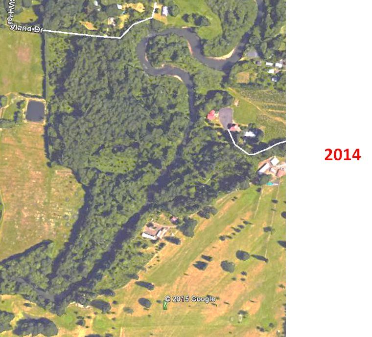
Marys River Continues to Change Course due to Dam Bypass
Google Earth Imagery (2014)
Note the continued erosion on both sides of neck of land just downstream from the former dam site. Also the overflow swale features are still present trending SW-NE across the former golf course. The Marys will very likely cut through the remaining narrow neck in the next few floods. Channel changes will then likely propagate downstream all the way to Avery Park.
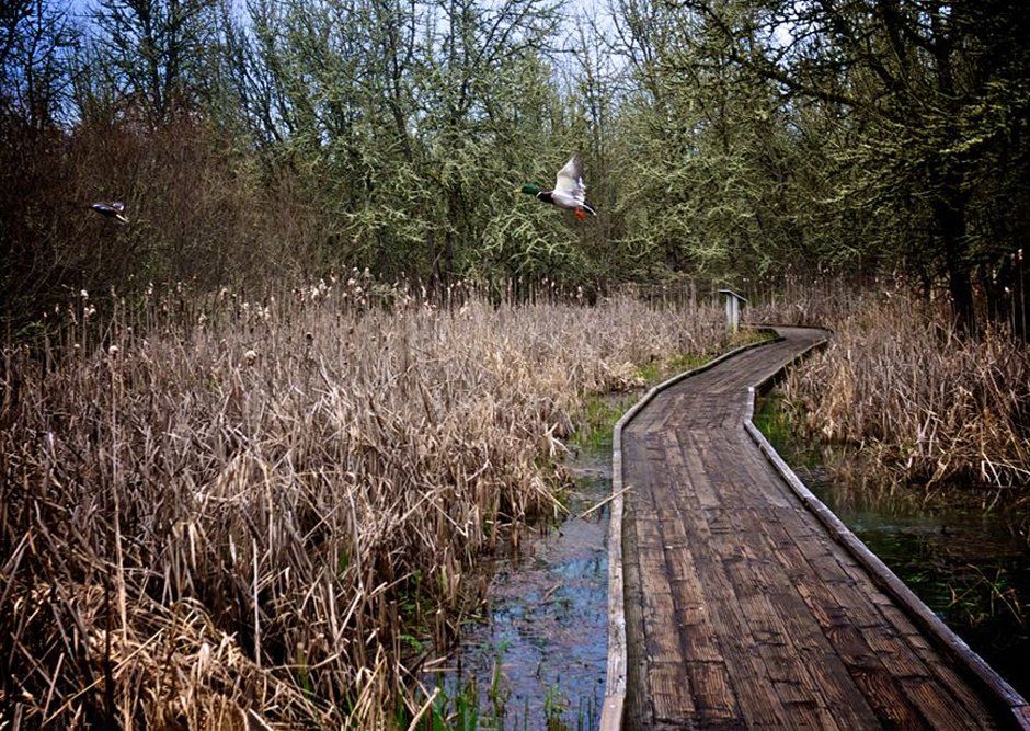
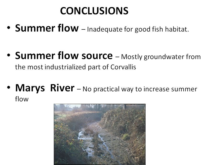
Mill Race Summer Flow
View upstream from bridge at Crystal Lake Dr.
Photo by Allen Throop (1997)
Flow stops in the Mill Race and only ponds remain, fed almost entirely by groundwater from the most industrialized part of Corvallis. These ponds become stagnant and provide little if any fish habitat. There is no practical way to increase Mill Race summer flow.

Acknowledgements
Doug Sackinger, Joe Mardis, Jason Hotchkiss (Benton County)
Regina Southworth (Marys River Watershed Council)
Linda Stevens, Kevin Loso, Clay Brooks, and Matt Gressel (City of Corvallis)
Mary Gallagher (Benton County Historical Museum)
Gary Chapman (nephew of Ralph Chapman)
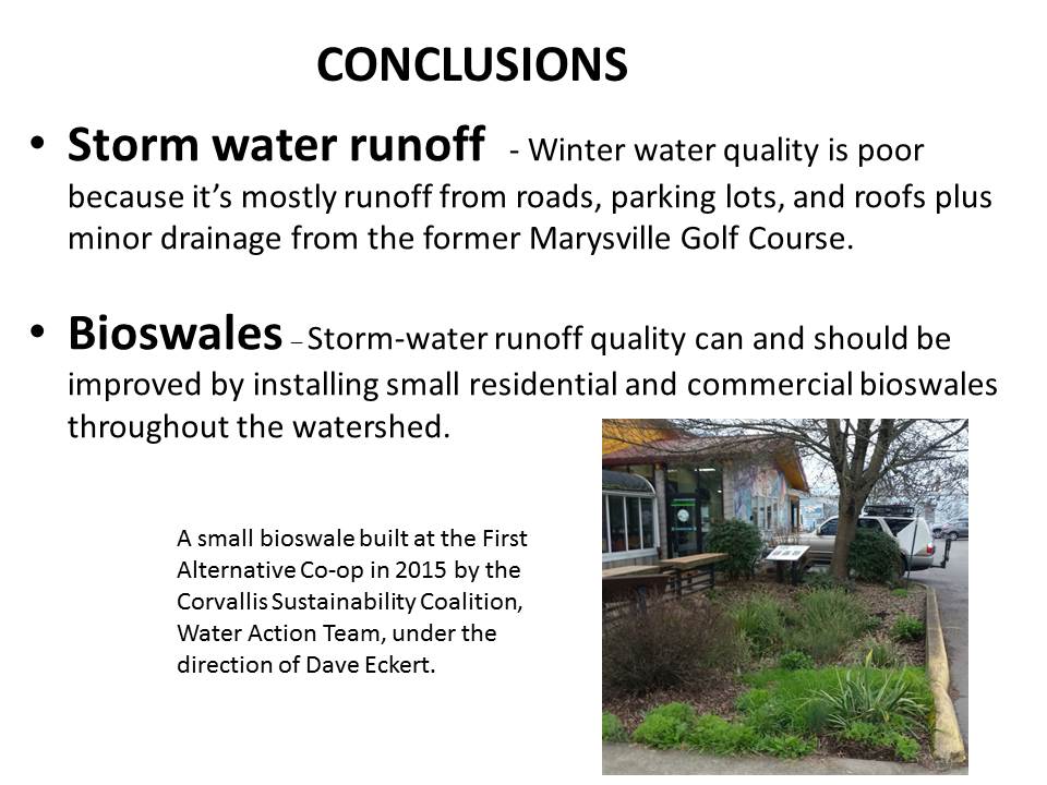
Dave Eckert (Corvallis Sustainability Coalition, Water Action Team)
Bill Gellatly (Marys River Watershed Council)
Charles Newlin (long-time Allen Street resident)
Meghna Babbar-Sebens (OSU College of Engineering)
Anita Ragan (H&V)
Bill Pepper (Pepper Construction)
OSU Library
U of Oregon Aerial Photo Library